St. Louis Lambert International Airport (STL)
Orientation and Maps
(St. Louis, Missouri (MO), USA)
One of the most important cities in the state of Missouri, St. Louis is most famous for its huge Gateway Arch, which towers high above much of the city. The iconic Gateway Arch has long been an important point of reference in St. Louis and dates back to 1965, being part of the Jefferson National Expansion Memorial.
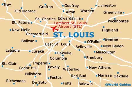
To the northwest of the city and close to both the I-170 and I-270 interstates, St. Louis Lambert International Airport (STL) is close to Bridgeton and Berkeley. With regular flights to all of the major cities in the United States, the airport is linked to downtown St. Louis by a series of buses, shuttles and the city's light-rail system.
St. Louis Lambert International Airport (STL) Maps: Important City Districts
Long-distance buses operate at the Greyhound bus station along North 13th Street, on the northern side of the city center. Nearby and to the southeast is Union Station on South 16th Street, where many Amtrak trains stop each day. The local buses in St. Louis are run by the Bi-State Transit System, together with the MetroLink light-rail.
Important districts around downtown St. Louis lie off Market Street, the area's main thoroughfare, and include Forest Park area and the University City Loop District. Also known as simply the 'Loop'. this part of St. Louis is a particularly trendy area and features some of the city's best restaurants and entertainment venues. The centrally located West End is a fairly upscale neighborhood, while the Hill is home to a friendly and vibrant Italian-American community.
USA Map
Missouri Map

St Louis Map